Conservation Hub Overview and User Guide
The ABRA Conservation Hub is a collection of tools and resources aimed at informing and empowering the conservation community by promoting and facilitating data transparency. ABRA leverages these tools to simplify, and communicate to stakeholders, data associated with the design, permitting and construction of infrastructure or land management projects that may have significant environmental impacts. This data is presented in the form of an easily navigable online map. Information relating to the laws regulating developer and agency actions and requirements, public comments or filed notices, and discussion of stakeholders’ concerns are also often included on a linked project information page. ABRA’s Conservation Hub is based on ArcGIS Hub, a community engagement platform that organizes people, data and tools through information-driven initiatives, and ArcGIS Online, a web-based GIS and data sharing platform. Using ArcGIS Hub, ABRA creates project or issue-focused websites that inform stakeholders, promote collaboration in the conservation community, and provide the information necessary to effectively engage with regulators. These project information pages link to online maps displaying project plans in an environmental context. The maps are made in ArcGIS, using data obtained from project developers, state or federal agencies, or partner organizations and volunteer groups, and published to ArcGIS Online.
Project Information Pages
Project Information pages typically contain descriptions of the proposed project or action and its goals, as well as concerns that have been raised about its potential impacts or consequences. ABRA posts on the information page project-relevant documents that have been made publicly available by project sponsors and regulatory agencies. These might include public notices of the project, scoping documents, site plans, environmental assessments or related studies, etc. Where applicable, ABRA may provide text excerpts or tables from these documents to quickly communicate project specifics. Comments, studies or legal objections to the project made by citizens and conservations groups are also posted. Often included are images of the proposed project area, species or habitats that may be impacted, or maps describing the action or impacts.
Conservation Web Maps
ABRA aims to keep online maps as simple as possible, while ensuring that relevant data and tools are available. Data layers representing project actions, administrative boundaries and basic environmental factors are always included. Additional data layers are included based on availability and relevance. ABRA uses a small set of mapping tools on most maps, though partners can request additional capabilities. Typically, the tools menu for ABRA web maps includes a Layer List, a Legend, a Measurement tool, Drawing and Annotation tool, Printing, and Basemap Selection. An Add Data tool is also included on some in-depth maps. Users can turn data layers on and off, change transparency or drawing order, go to the data description, etc. Distances and areas can be measured and XY coordinates captured. Shapes and text can be added to the map, printed and shared in PDF format. Additional data can be added from ABRA’s data catalog or from all of ArcGIS Online’s data holdings. Users can link back to the project information page, the Conservation Hub homepage, and a map description page that includes links to data details.
GIS Data Sources and Documentation
Data is taken from an authoritative source whenever possible. Typically, this means state or federal agencies (Department of Environmental Quality, USGS, USFWS, EPA), project permit documents, nationally known and vetted conservation organizations (Trout Unlimited, NRDC, Center for Biological Diversity), or trained staff and volunteers of local and regional conservation organizations. Documentation for data displayed in Conservation Hub web maps is accessible through links associated with each item in the layer lists and through links associated with individual features displayed on the maps. In addition, an ABRA GIS Data Catalog is maintained, providing documentation for all data layers used in ABRA web maps.
Data is documented in the following fashion: Purpose – what does the data describe and why is it included? Source & Date – from where did ABRA acquire it and when? Processing – what did ABRA do to the data to make it “fit” into our GIS structure? Symbology – either how it is seen in its related online map (if only one) or its default symbology (if used across multiple maps). If metadata or descriptions were included with the original data (this is actually quite rare...state agencies, especially, do quite a poor job of providing online data documentation), it is included after the Symbology description. Wherever possible, links to the data’s download site or report from which it was taken is included. Tags and Categories are assigned to make searching easier, and the source is noted, and often linked, in the Credit section.
Data for Conservation Hub maps is mostly hosted on ABRA’s ArcGIS Online cloud account. However, some data, hosted and maintained by authoritative sources, are referenced directly from those sources. This increases data accuracy and reduces our maintenance workload. Data that ABRA hosts and maintains is also stored in a data catalog on Dropbox. The Conservation Hub has a dedicated storage structure for project-specific data and a separate structure for contextual layers (administrative boundaries, regional geology, land use, flood risk, etc.) that are used by many projects.
Data processing and assembly requirements depend heavily on the data type, the format in which it is received, and its purpose, or how it fits into any maps from which it may be referenced. For example, water quality monitoring data is typically received from a lab in their proprietary tabular format. Data field names and structures may be incompatible with a GIS database and location coordinates are rarely included. This data table must be “rebuilt” into a GIS-friendly format, QA/QC’d and reviewed before it can be published. ABRA may simplify data by merging boundaries or combining feature types (ex. Five soluble carbonate rock types renamed “karst”). This type of operation is planned beforehand by ABRA’s Conservation Hub team. All processing is described in the Processing section of the data description. Whether a data layer will be included in a map is discussed in terms of “what does is provide that current or other data do not”? If the layer is deemed potentially helpful, it is included.
ABRA GIS Data Catalog
All GIS data used in ABRA web maps, including data that ABRA hosts and data hosted by others, is maintained in a searchable online database, the ABRA GIS Data Catalog. This catalog provides brief descriptions of data layers and links to additional information.
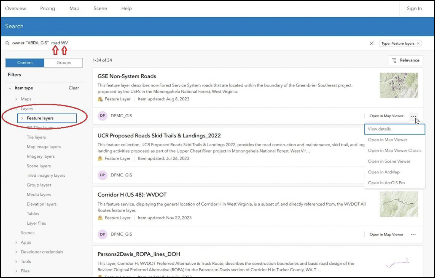
To access the catalog, which is hosted on ArcGIS Online, follow the link above or select Data Catalog from the menu at the top of ABRA web maps. There you will see a list of all publicly available layers hosted by the ABRA Conservation Hub. This list of data layers may be filtered by selecting the Item Type options on the left side of the screen. In the image below, the Layers item type has been expanded and the Feature Layer subtype has been selected. The catalog can be searched by entering search terms in the Search bar at the top of the list. Initially the term “owner:DPMC_GIS” displays. This term should be left in place, as it restricts results to only those hosted publicly by ABRA Conservation Hub. Without this term, everything on ArcGIS Online is made available. Additional search terms may be added after “owner:DPMC_GIS”, and simply separated by spaces. In the image below, “roads” and “WV” (for West Virginia) have been added. The search terms return layers with either of those terms in the Tags, Title, Summary or Description section of the layers’ Item Details pages. Enclosing the terms in double quotes would return layers that have the exact phrase “roads WV” in those sections

The Item Details page for each layer can be accessed by clicking on the layer title in the list, or by clicking the ellipsis on the right of each layer listing and selecting View Details.
Adding ABRA GIS Data to Web Maps
Searching the ABRA Data Catalog from the online maps works similarly, though some additional button-pushing is required to actually get the data into the map once found.
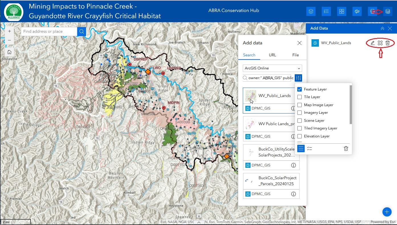
- To search the ABRA Data Catalog from our online maps, click the Add Data tool (stacked-disk symbol for a database) on the right side of the toolbar. For instructions on using all of the features of the Add Data Tool, click here.
- If you have not already added data, a blue box will prompt you to add data...click it.
- If you have already added data, those layers will appear in a list and a blue plus sign will be shown at the bottom. Click it.
- The add Data dialog appears. With the Search tab active, and ArcGIS Online selected, type “owner:”DPMC_GIS” into the Search bar. Then add additional terms as necessary. There is a Filter button to the right of the Search bar. Use it to limit your results by data layer type (feature layers, tile layers, etc.). ABRA uses Feature Layers, Tile Layers and Group Layers almost exclusively.
- Click any of the listed data layers. It will be outlined in blue if selected. Click the Done button when you have finished searching and selecting data layers.
- To the right of each added Data Layer name are three buttons. The middle one (four circles arranged in a square) is the Actions button. From here you can add each layer to the map. The edit button (pencil) allows you to change the layer name for display in the map. The trash can will remove the layer from the Add Data list.
- When you are finished, click the “X” at the upper right to close the Add Data tool, or select another tool from the toolbar.

Adding Data from Other Sources
Adding data from other sources is similar, if using the Search tab. Simply remove “owner:DPMC_GIS”, and add search terms of your choice. You can use the AND operator for multiple search terms, or simply use a space. As above, enclosing two or more terms in double quotes will return data with those terms in that exact order in either their Title, Tags, Summary or Description.
Users can also add data directly from other GIS servers, provided they know the data source address. Simply paste the URL into the appropriate text box on the URL tab.
Finally, users can upload their own data, in zipped shapefile and other formats.
For more information one searching for and adding GIS data with the Add Data Tool, please click here to access ESRI’s own documentation.
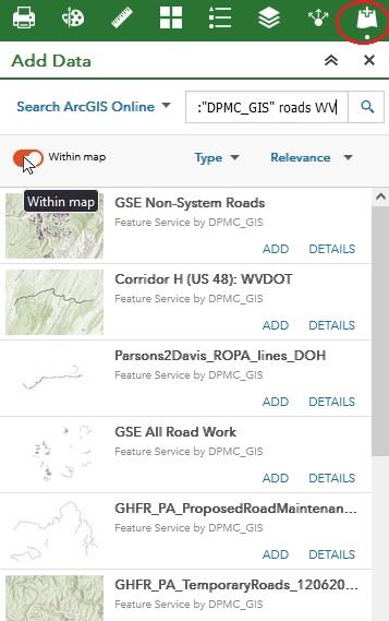
If the Add Data Tool does not look or behave quite as described above, you may be accessing a web map that uses the older Web App Builder. You will find documentation for that version of the Add Data Tool here.


